There is a famous, slightly unbelievable story from the Brisbane floods of January 2011: that bull sharks were seen swimming in the streets of Goodna.
It was widely reported at the time. The Wikipedia entry on the floods still records it dryly as “a rare plausible claim of sharks swimming in a flooded urban area, with reports of bull sharks swimming in two streets in Goodna’s centre.” The image is hard to shake — fins cutting through the brown water above the white lines of a suburban Queensland intersection, a fish that ordinarily lives at the mouth of the Brisbane River nosing past the windows of a flooded petrol station.
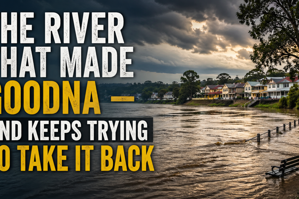
It is also an almost perfect emblem of Goodna, a suburb whose entire history is a long, complicated argument with the Brisbane River.
The river is the reason the suburb exists at all. The river is also the reason it has, three times in the last century and a half, very nearly been destroyed.
A waterhole called Woogaroo
Before it was Goodna, the place was Woogaroo.
The name, recorded on Robert Dixon’s 1840 map of the Moreton Bay District, came from Woogaroo Creek, which formed the eastern edge of the area and emptied into the Brisbane River. In the local Aboriginal language, “Woogaroo” referred to a waterhole in that creek. From the very first European naming, then, the place was defined by water — by a specific pool of it, to which people came.
The land sits on Ugarapul country, where the Ugarapul people had lived and managed the river country for thousands of years before John Oxley’s exploration party rowed up the Brisbane River as far as this point in 1824. Patrick Logan, the brutal commandant of the Moreton Bay penal colony, came next. By 1826, Logan had established the Woogaroo Quarry to cut sandstone from the rich beds along the river — stone that would be shipped downstream to build the foundations of colonial Brisbane. The river was the road, the quarry was on the riverbank, and the relationship was set: Goodna’s economy was a river economy.
When the village was officially proclaimed in 1856, it was still called Woogaroo. The name didn’t change to Goodna until 1865.
A wharf, a paddle steamer, and a silver spade
For most of the nineteenth century, Goodna’s life happened on or beside the Brisbane River.
Bullock teams hauled timber out of the surrounding forests and down to the Goodna wharf, where it was loaded onto barges and steamers and shipped down to Brisbane or up to Ipswich. The sandstone quarries kept producing — a second great wave of stonecutting fed the Brisbane building boom of the 1880s. Cobb and Co coaches stopped at Goodna on their daily run between Ipswich and Brisbane, the only other stops being Oxley and Rocklea.
Then, on 30 January 1873, came what may have been the single biggest day in Goodna’s nineteenth-century history. The “turning of the sod” ceremony for the new Brisbane–Ipswich railway was held in Goodna. Two thousand people attended. Most of them arrived by paddle steamer — a flotilla of pleasure boats coming up the river to a small farming village. The Queensland Governor, George Phipps, the 2nd Marquess of Normanby, did the honours with a solid silver spade, lifted a small piece of earth, and deposited it ceremonially in a wheelbarrow. Two thousand people watched, ate, and were generally festive. Then they got back on their paddle steamers and went home.
By 1888 the population of Goodna was around 500 souls. There was a state school (1870), a Congregational church (1863), a sawmill (1884), a blacksmith (1870), several stores, a hotel, and a cemetery (1859) on a low rise that — significantly, and intentionally — sat well above the floodplain.
The town that had grown up beside the river was, in nearly every sense, a creation of it.
1893: The flood that turned the railway station around
And then, in February 1893, the river took its first big swing back.
A series of cyclonic systems dumped extraordinary rainfall across the Brisbane catchment. The river broke its banks and rose to heights that have only been matched twice since (in 1974 and 2011). For the small farming community of Goodna, the result was something close to apocalyptic.
The chemical factory on the river flats was destroyed. The Primitive Methodist Church was lifted off its foundations and carried bodily downstream — eventually rebuilt later in Smiths Road, where it stood until being demolished in 1984. Most extraordinarily of all, the Goodna railway station — the same station that twenty years earlier had been the proud destination of the Marquess of Normanby’s silver spade — was lifted whole by the floodwaters, rotated completely around by the current, and dumped back down on the rising ground, still intact. Surviving the flood only to be burned down some years later, which has the air of a cruel joke at the station’s expense.
Residents took refuge in the school. When the waters finally went down, they came out and started rebuilding.
This is the pattern the suburb would learn by heart over the next 130 years: river rises, takes everything, leaves, residents rebuild, river rises again.
1974: The lesson half-learned
Most of the twentieth century passed without a major flood. There were small ones, of course — the Brisbane River is not a docile body of water — but no defining disaster. New houses went up on land that hadn’t seen a real flood in living memory. Caravan parks were built on low-lying ground next to the river. The Ipswich Motorway was put through. Goodna grew from a sleepy farming village into a working-class outer suburb of Brisbane, with all the postwar accoutrements.
Then in January 1974, after weeks of rain associated with Cyclone Wanda, the river came back.
The 1974 flood is the one that older Goodna residents still talk about with the kind of awe usually reserved for biblical events. Whole streets went under. The Giles Caravan Village, on low ground beside the motorway, was completely submerged; two lives were lost there. Houses that had stood dry for eighty years filled with brown river water. Many were gutted. Some were never restored.
There was, in the years afterwards, considerable conversation about what the right response should be — relocation, levees, planning controls, dam mitigation. The Wivenhoe Dam was built, partly in response to 1974, with the understanding that it would attenuate future flood peaks downstream. Many Goodna residents were told, when they bought into the suburb in the years that followed, that the dam meant a 1974-scale flood couldn’t really happen again.
2011: When the river came for everything
On the night of 12–13 January 2011, the Brisbane River peaked at 4.46 metres at the city gauge.
Goodna and Gailes were named in nearly every report as the worst-affected suburbs in the entire Ipswich area. Of the 2,647 dwellings in the suburb, roughly 600 were completely inundated. The St Ives Shopping Centre — the suburb’s main retail strip, sitting on low ground a short walk from the train station — went under by almost two metres of water. Only three of its twenty-five-odd businesses had flood insurance. Two nearby petrol stations were submerged completely; fuel leaked out of their underground tanks and added a bright slick of contamination to the brown water rolling down the street.
The Giles Caravan Village, which had been rebuilt after 1974, went under again. Caravans were ripped from their blocks by the current and deposited fifty metres away, piled on top of one another like a child’s toys. None of the residents — many of them pensioners on fixed incomes — had insurance. At the peak, an eight-metre light pole in the caravan park was completely submerged. A park bench was found wedged in the high branches of a tree afterwards, marking the high water line.
And somewhere in those streets, plausibly enough that the story made the official record, the bull sharks came up out of the river.
In the weeks that followed, the so-called “Mud Army” descended on Goodna — thousands of volunteers in gumboots and shorts, hauling sodden carpet and ruined furniture out of the houses and into vast piles on the kerbs. The whole suburb smelt of wet drywall and river silt for months. Some homes were demolished. Some businesses simply never reopened. People who’d been told the dam meant they were safe sat on their front steps and did the maths on their losses.
2022: Less famous, just as wet
And then, eleven years on, almost as if to make a point, it happened again.
The February 2022 floods didn’t reach 2011 levels at the Brisbane River gauge — peaking at 3.85 metres — but the rain pattern was different and many low-lying areas were hit hard. Goodna was once again in the news. A man went missing from the suburb during the floodwaters and was the subject of a police search. Homes that had been rebuilt after 2011 went under for a second time in just over a decade.
Insurers, who had spent the years since 2011 sharply rewriting their flood policies and premiums, were less surprised than the residents.
Why people still live here
If you’ve never been hit by a flood, the obvious question is: why does anyone stay?
The answer is partly the answer Australians always give: it’s home, and where else are we going to go? It’s partly economic — Goodna remains one of the most affordable suburbs within commutable distance of central Brisbane, and people on modest incomes don’t have the luxury of relocating to the dry leafy western suburbs at will. It’s partly the community — Goodna has a vibrant Samoan, Vietnamese and Pacific Islander population that has put down deep roots over decades, with networks of family and church and school that don’t pack up because the river misbehaves. It’s partly the trees: jacarandas, poincianas, hoop pines and great old mango trees lining the streets, the suburb still hosting its annual Jacaranda Festival every October since 1968, drawing 10,000 visitors at a time.
And it’s partly something harder to name. People who have lived through a flood and chosen to come back tend to develop a particular relationship with the place that took everything from them. They know exactly what they have. They are no longer surprised by anything the weather can throw at them. They watch the river, and the river watches them, and the relationship goes on.
The cemetery, opened in 1859, still sits on its low rise above the floodplain — exactly where the early settlers put it, on the only ground they knew the river couldn’t reach. Even in 1893, in 1974, in 2011, in 2022, the dead of Goodna stayed dry. The town’s nineteenth-century planners may not have got everything right. But on that one point, they understood the local geography precisely.
Goodna is a river suburb. It always was. It always will be. The waterhole called Woogaroo gave it a name, the river built it, the river broke it three times, and the suburb is still there, rebuilding for the fourth time. Whether the fourth time is the last time depends on a great many things — the dam, the climate, the planners, the sky.
The river will keep flowing past either way.